What to expect of Hunza? Of course, I was intrigued by the fact that James Hilton used this lush green valley as inspiration for his utopian place Shangri-La in Lost Horizon. When you travel the Karakorum Highway (KKH), though, the horizon is anything else than lost anymore. China has invested billions in expanding the road here to build a connection from its far West to the Indian Ocean in Gwadar.
Since then, the lost, mysterious vibes have vanished. The valley is flooded by Pakistani and foreign tourists in summer. This trend has been going on for around seven years, just briefly interrupted by Covid-19. The locals are still enthusiastic about tourism, and visitors have indeed brought more prosperity and quality of life to the valley.

Nevertheless, there are still some things in which the Hunza Valley lags in terms of comfort. The electricity often fails, the phone network is unstable, and you've got to shower cold. That is a bit of a problem when you come in late fall to enjoy Hunza without large groups of tourists. But it's bearable for a while.
The places in Hunza vary a bit from quite popular and touristy to remote and unknown. Pakistani visitors, for instance, don't really tend to go hiking. That's why many of the tracks are still quite empty. Unless, of course, it's high season.
Gilgit – The Gateway to the Hunza Valley
Gilgit is the largest city in Gilgit-Baltistan and the gateway to Hunza as well as to Nagar and Skardu. Most travelers coming to the region will have to make a stop here because the journeys from Islamabad or Chitral are pretty long: I was always given rough estimates ranging from 12 to 20 hours.
Once you arrive, you want to rest, fill up your tanks, buy food, warm clothes, and withdraw money. You can even find a few Western supermarkets with all you need for your trip. Apart from that, the city is not particularly great, but it is a good supply point. Plus, in the surroundings, you can have a look at the carved Buddha image on a rock near the Kargah and Shukogah Rivers as well as at the Henzal Stupa. Both of them are situated West of Gilgit. I didn't have time for that, since this 14 h trip from Mastuj had drained my energy way too much.

(Source: Wikimedia, Mirbasit, CC BY-SA 3.0)
To get further, you can visit one of the small minibus stations with departures in the directions of Hunza, Nagar, Skardu, and Mastuj. You find these stops easily on MAPS.ME. The departures start comparatively late, around 9 am, and end before sunset. At 500 to 1000 Rupees, the tickets are far cheaper than the alternatives, especially cabs.
The buses leave as soon as they are full, which means that at least 18 people must be on board and the luggage heaved up on the roof. So if the local staff says that they will be leaving in half an hour, but there are only five people on the list: Ignore the statement, go to the nearest restaurant, relax, and chill for the next 90 to 120 minutes!
Karimabad – Historic Place with Baltit Fort
If you want to enjoy a full load of local culture, arts and crafts, and historic architecture, Karimabad is the place to be. The township is home to the imposing and legendary Baltit Fort built in the 8th century CE. Until the 20th century, it was home to the Mir of Hunza, the prince of this little mountain kingdom. Therefore, a peek inside offers you an unforgettable journey through time, with many exhibits from the era of the Great Game between the British Empire and the Russian Tsarist Empire on display.

(Baltit Fort)
Below the fortress and on the way up to the complex, you will pass many stores selling regional handicrafts and Hunza's most famous seasonal specialties, from pears and apricots to apples and walnuts – also available fresh, dried, liquid, or as jam.

(View from Baltit Fort over Hunza)
A little further away from the center, you can visit the second fort, called Altit, and drive up to the Eagle's Nest, from where you have a great view of the Rakaposhi group. There are also various hotels, glamping sites, and cafes. I hitchhiked up to this viewpoint, but noticed that there were hardly any cars coming back towards evening, i.e., after the spectacular sunset. Therefore, it makes sense to have your vehicle or book a cab. In my experience, it takes a good hour to walk back downhill in the dark. Doable, but perhaps annoying for some.

(View from Eagle's Nest)
All in all, Karimabad is one of the most beautiful and currently most touristy places in Hunza. Various high-quality hotels and homestays offer their services. However, according to my local contacts, the bazaar and alleyways can get uncomfortably crowded in summer. At the time of my trip, in November, there was still enough space to explore the city. My tip for misanthropes: Choose the low season!

(Ladyfinger Peak from Eagle's Nest)
In the lower town, i.e., around the market, electricity is available almost all the time. During my stay, I had retreated to the original neighborhoods for couchsurfing, where the electricity fluctuated, and the cell phone had to be positioned very precisely in one way or another to catch the signal.
One downside to Karimabad: As of November 2024, 3/3 ATMs didn't work, at least with my Visa card. To withdraw money, I first had to travel to the regional center of Aliabad or even to Gilgit. This is also likely to change in the coming years. In some cafés like the Mountain Cup, you can already pay electronically, of course, only if the network is working.
Aliabad - The Supply Center in Hunza
After Gilgit, Aliabad is the second major supply center in the wider Hunza Valley. It is located around two hours from the provincial capital and is characterized by its very well-developed bazaar. The Karakorum Highway goes right through the town and market, so conveniently you don't have to get too much out of the way to go shopping. Apart from stores, you will find plenty of restaurants and cafés as well as functioning ATMs!

(Best bet: Bank Alfalah)
If you need cash in the Hunza Valley, it is currently almost impossible to avoid a stop in Aliabad. Your best bet is the Bank Alfalah. For a road trip, the town is also a perfect stopover, as you don't have to descend from the mountain like in Karimabad, but you are right on the highway. Karimabad itself is only 20 to 30 minutes away. The nearby Pissan Nasirabad RCC bridge also provides flexible access to the Nagar Valley.
Lake Attabad – The New Leisure Paradise
I did plan a little stop at Lake Attabad, but certainly not as part of a classic tour where a guide takes you from one place to another. It turned out differently. As hard as I tried to hitchhike – I quickly stopped a car – there were no locals to pick me up. Instead, the guide and driver of Cristiano from Manchester pulled over and gave me a lift, probably at the customer's behest.
We agreed that I would come with them to Lake Attabad and then to Hussaini. The conversations were quite stimulating and, as so often, I asked the local person what they thought of tourism. Everything was great and bringing prosperity, the driver replied, quickly adding praise of foreign visitors and describing the travelers from Pakistan as problematic. I had already heard similar things in Kashmir about tourism within India.

(Lake Attabad)
Lake Attabad is an outstanding example of how nature in Hunza suddenly becomes a Disneyland-like attraction. The lake was formed about 15 years ago, when a landslide caused the village of Attabad to fall into the Hunza River. 20 people died that day in early 2010, and the massive rocks collapsing blocked both the Karakorum Highway and the water.
Today, the disaster of that time is more of a blessing for the regional economy. I expected a beautiful, turquoise-blue lake with idyllic views. Hunza—the mysterious kingdom in the mountains, hidden behind lost hori..., well, it's all different. In reality, the Chinese road has boosted tourism, and the aforementioned Lake Attabad is a small fun park for those who are carted here.
When we got out of the tunnel, I spotted blue water, stores, and restaurants, jetties, jet skis, and ziplines. Let's put it this way: at this level, everything is still reasonable. The amusement park spans over a relatively limited area and is particularly popular with some Pakistani vacationers as an action option. Good for a day trip, and there are also a few hotels around.

(Jetskis at Lake Attabad)
It took my temporary companion, Cristiano, about 45 minutes to ride a jet ski and glide from one side of the bay to the other on the zipline. Finally, he got back by boat and, after I had eaten my delicious local meal – Chap Shoro, a stuffed crispy flatbread pastry – we got back into the car.
Conclusion: Attabad is good for a bit of action, absolutely family-friendly, all in all still reasonable in terms of sustainability, as long as the entire Hunza Valley doesn't turn into an amusement park at some point.
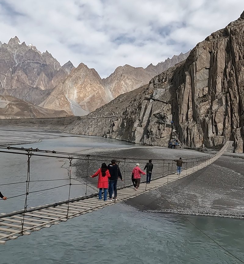
Hussaini – "Deadliest Bridge in the World" (NOT)
Hussaini was the second stop on my short hitchhiking tour with a guide. The visit to this sight was logical and on my secret schedule as well, since the village is home to the "most dangerous and deadliest" suspension bridge in the world – at least if you believe all the YouTube clickbait. In reality, it's a quite popular landmark visited by thousands from babies to 99-year-olds (just guessing). With a few admittedly sturdy-looking wire ropes stretched across the gorge and wooden planks laid over it at large intervals, it wouldn't pass European security standards, to be fair. But crossing it without certain death is quite likely.
(Obligatory picture of Hussaini, the "deadliest bridge in the world")
The bridge itself, I assume, will not collapse any time soon. Visitors pay 500 Rupees, and this money is used for maintenance. But true, of course, I wouldn't bet on the tourists being able to walk. The gaps are comparatively large and, despite my growing belly, I would easily fit through them only to end up in the icy water of the River Hunza. Even if you get stuck between the planks, I'm sure it wouldn't be that comfortable.
In theory, of course, it is quite simple, and on the ground, you can easily manage to get your foot in the designated areas. At altitude, however, some people may feel dizzy, especially as the current of the river below can cause some confusion.
(Hussaini Suspencion Bridge)
Nevertheless, the Hussaini Bridge is a must-see in Hunza. If you are not afraid of heights and have the confidence to place your feet correctly, you will have a lot of fun here. Once you reach the end, it looks as if this deadliest bridge in the world leads to nowhere. At the edge of the cliffs, however, there is a small path that brings you to Zarabad and Khuramabad. These villages are barely inhabited and are mainly used as farmland.
Incidentally, Hussaini is not the only dizzying, most dangerous bridge in the world. Anyone traveling the Karakorum Highway will discover many such structures in both Gilgit-Baltistan and Khyber-Pakhtunkhwa. It's worth stopping here individually and asking the locals if it's safe to cross. That would surely make it a bit more of an exclusive experience.
Borith Lake – Hidden Gem, But Barely Worth a (November) Hike
While visiting the Hussaini Bridge, a surprisingly not-so-rare occurrence took place. Two British Pakistanis, who had already taken me up to the Eagle's Nest in Karimabad some days before, were also ready for their crossing at the very moment I returned from my walk. In the end, they only made it a third of the way due to the onset of vertigo. Opportunity enough to have a little chat with them about traveling in Hunza.
I finally suggested to the two of them that we drive up to a mountain lake called Borith. It would take almost an hour on foot, ten minutes at most by car. When I had looked at the pictures beforehand, I wasn't really convinced that it would be worth the hike. But by a car, I sure would give it a try, and so we hurried to this lesser-known attraction.
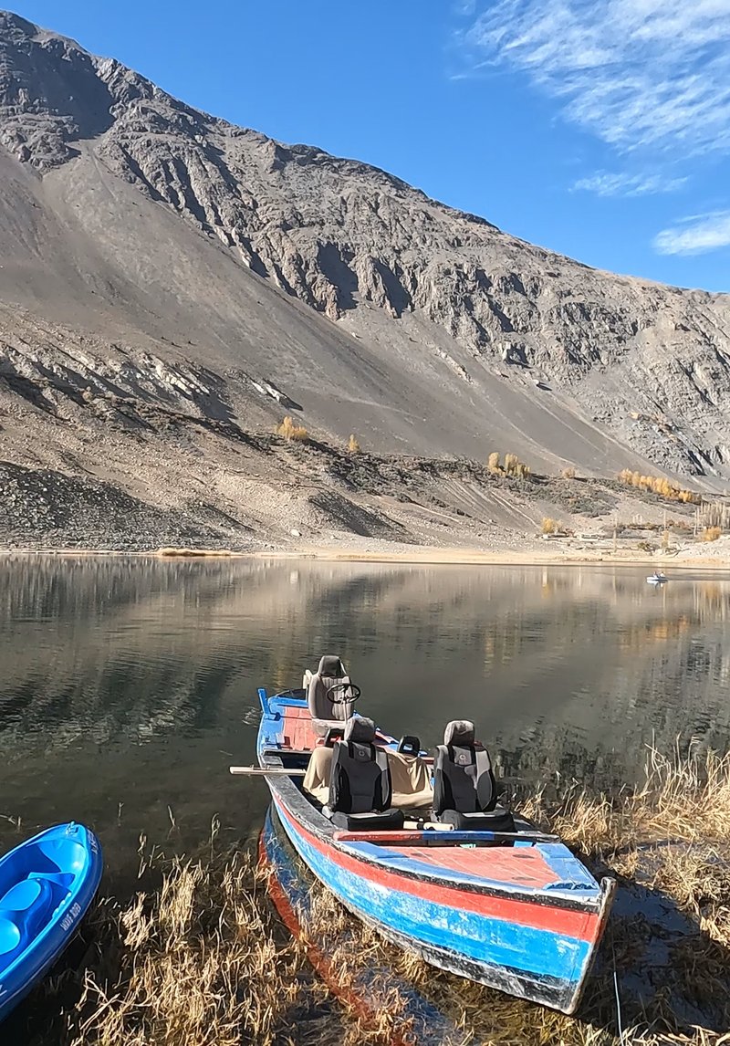
(Lake Borith)
There were a few boats there too – in this case, for rowing or pedaling. The pictures I had in my head at least showed a beautiful reflection of the snow-covered mountains on the water's surface. When we arrived, however, the place looked rather muddy and grey.
Conclusion: Nice to see, but not a must (in November). It's certainly busier in summer, and then you can also stop for grilled fish in one of the restaurants at the shore. There are also a few nice corners, where you could pop up a tent for a night on your hike higher up.
Passu Cones – Amazing Rock Formations
My stop at the Passu Cones was more of a coincidence. Poor preparation meant that I didn't know anything about these imposing rocky peaks. After visiting the Hussaini Bridge and Lake Borith, I waved my thumb on the Karakorum Highway, hoping for a ride. I went for a little walk, enjoyed the scenery, and eventually, a mini truck pulled up. The men inside mentioned they are going to Passu and pointed to the back.
(Hitchhiking on the back of a truck)
I quickly jumped up, knocked on the metal to signal my readiness, and off we went on an exciting ride across the Karakorum. Behind a curve, they finally appeared: the rugged peaks known as the Passu Cones.

(Passu Cones)
I've been very lucky. The truck suddenly pulled over and stopped at the best viewpoint for this natural wonder possible. The men got out, I looked over the edge of the truck bed and discovered the flat tire. They did their job quickly, but still it gave me about 15 minutes to enjoy the scenery to Pakistani old-school music from their speakers. Sure, I could have stopped the next car, but why rush? After they had fixed the problem, we continued for about two more kilometers, and I was free to jump into the next vehicle.
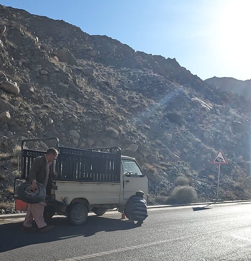
(Changing the tire)
Morkhun/Jamalabad – Small Village in the Mountains
One of my couchsurfers seemed to be in love with Jamalabad and strongly recommended going there. That's why I asked the drivers, who were actually on their way to Sost, to drop me off at the crossroads. These are located in Morkhun, right behind the bridge over the Shikarjerah River. From here, the road leads through a beautiful poplar forest and up a bumpy dirt road to the small settlement. Luckily, just as I was about to ascend to the top, a van turned up and invited me in.

(Local fruit trees in Jamalabad)
Well, there's not much going on in Jamalabad. But the white mountain peaks and the reddish rock along the banks of the River Hunza stand out against the roofs of the stone houses laden with hay. Everything contrasts with the trees, at the end of the year, covered in yellow-red leaves, which make for exciting panoramas.
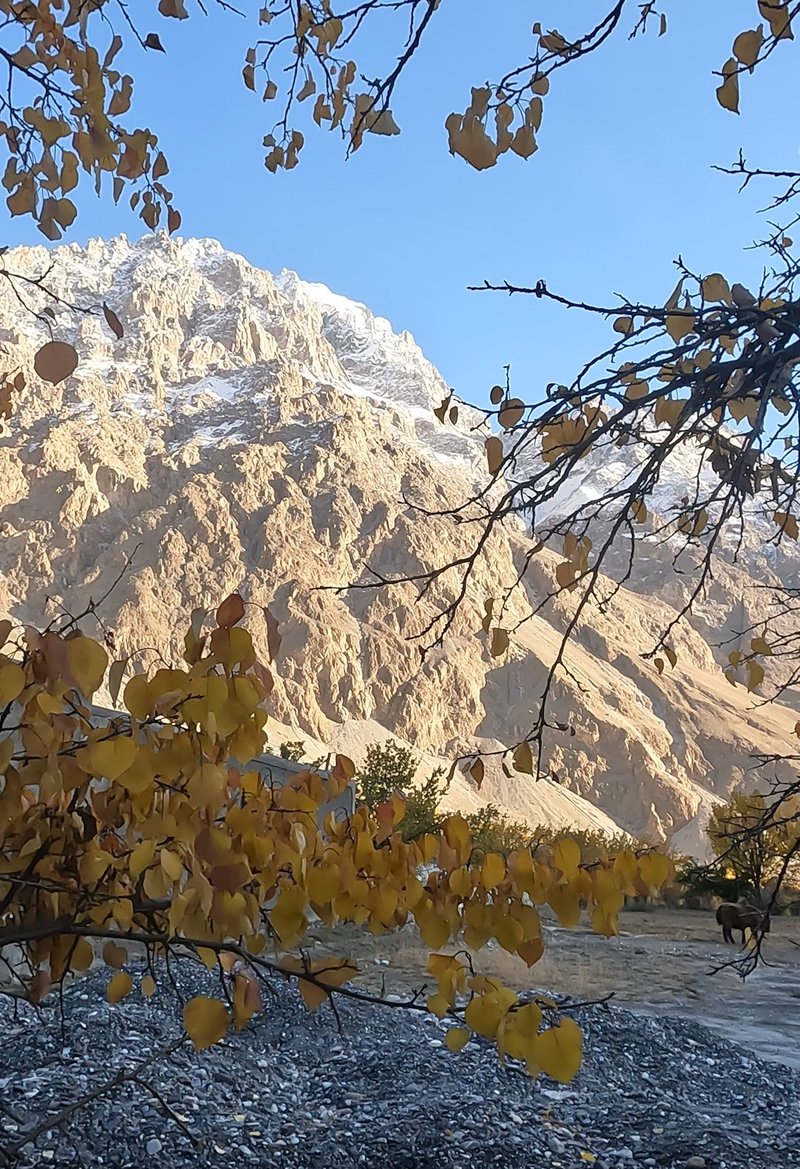
(Jamalabad)
My visit to Jamalabad was very short, for a reason. If you're lucky, you might meet a few locals and be invited for tea. The village is relatively unsuitable for overnight stays – at least I didn't see any official accommodation. But there are a few options in Morkhun. Therefore, it's more common to just have a short stopover and stay in a hotel in other villages, such as Sost.
Khyber – Good Starting Point for Hikes
Khyber is a fairly prominent village located between Sost and Passu, which is quite suitable for a stopover. The area, inhabited by Wakhi and Burusho, is mainly characterized by orchards and gardens. Of course, you can also enjoy the view of the rugged mountain peaks of Kirilgoz and Shanoz.

(Mountains around Khyber)
Overall, the location is ideal for excursions in the surrounding area, especially on the hiking trails to Passu. The village is famous not least for the Shaujerab glacier, which is a local attraction. Incidentally, winter is the hunting season, with locals and visitors mainly hunting ibex. This is one of the few places in Hunza where that's permitted and regulated.
If you drive through the municipality, you will discover several homestays and guesthouses. It is not a problem to find accommodation here. In summer, it may be advisable to book a room early, as the valley gets relatively full.
Minapin Nagar – Gateway to Rakaposhi
Historically, Minapin Nagar and Mt. Rakaposhi nearby are not part of Hunza. Until the 1970s, before both joined Pakistan, Hunza was one kingdom and Nagar another. The Nagar valley lies right on the other side of the river. When people travel from Nagar to Aliabad, they always refer to their journey as going to Hunza.
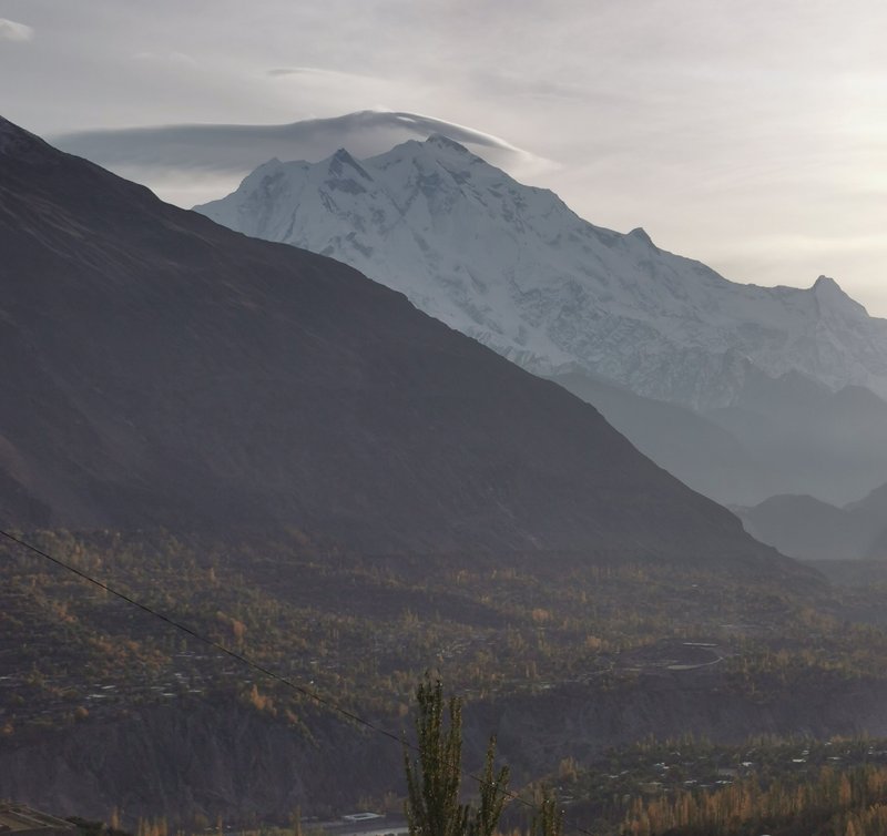
(Rakaposhi)
However, Minapin and the nearby village of Pissan can be reached very quickly and easily from the Karakorum Highway. That is, if you don't ride in on the back of a brick transporter, like I did. The construction workers were kind enough to let me sit right up on the top of the ash-coloured stones, despite their pleas to take a seat in the driver's cabin. After all, you have much better views from the back as the vehicle slowly jolts and jerks its way along the dirt tracks.
(Hitchhiking on the back of a brick transporter)
The main things to see are the snow-covered peaks of the Rakaposhi range and the 7,788 m high Rakaposhi itself. Minapin Nagar is, therefore, a perfect starting point for hiking and mountaineering. It takes about three to four hours to reach the base camp on foot. Before that, lush alpine meadows with small farms and beautiful forests open up before you. The first section is relatively strenuous, as you have to fight your way up the hairpin bends to the pass.

(Steep hiking path to Rakaposhi)
Alternatively, you could jump on a jeep. However, my idea of perhaps stopping a car halfway along the route soon proved to be unrealistic. There may be more traffic on this track in summer. Otherwise, cabs and tours can, of course, be organized to shorten the trip to Rakaposhi. The return on foot is relatively quick. It took me a maximum of 90 minutes to get to Minapin. Originally, I had planned on three hours. The whole hike can probably be completed in around five to six hours. Considering the stunning nature and the altitude, there's nothing wrong with longer breaks and a refreshing chai at the base camp.

(Little valley before the ascent to Rakaposhi basecamp)
Sost – Gateway to Xinjiang
Sost in the very North of the Hunza Valley is the gateway to the Khunjerab Pass and thus to the border with China. At 4,693 m, it is the highest border crossing and – for whatever reason worth mentioning – the highest functioning ATM in the world. It is about 85 km from Sost to the border, i.e., a 90 to 120 minutes' drive – and the whole complex is an attraction in itself.

(Source: Wikimedia, Sheikh Danish Ejaz, CC BY-SA 4.0)
Sost is a typical trading hub, where truck drivers stop to refuel, import-export companies handle goods, and different cultures come together. In addition to local Wakhi, Burosho, Shina, and Balti, you can meet Chinese commercial travelers, Pakistani truckers, Afghan workers, Badakhshan craftsmen - in short, one of those wonderful, sometimes harsh places where cultures mingle.
Yes, Sost may not impress with historic architecture or spectacular nature in the immediate vicinity. But you can sense that something is on the move at every corner and just sitting in one of the trucker restaurants and spying on people can give you interesting insights: With what kind of conduct do the Chinese businessmen come in here, with what energy do the Wakhi workers make their way to Xinjiang, with what kind of enthusiasm do the Pakistani drivers clean their colorful trucks?

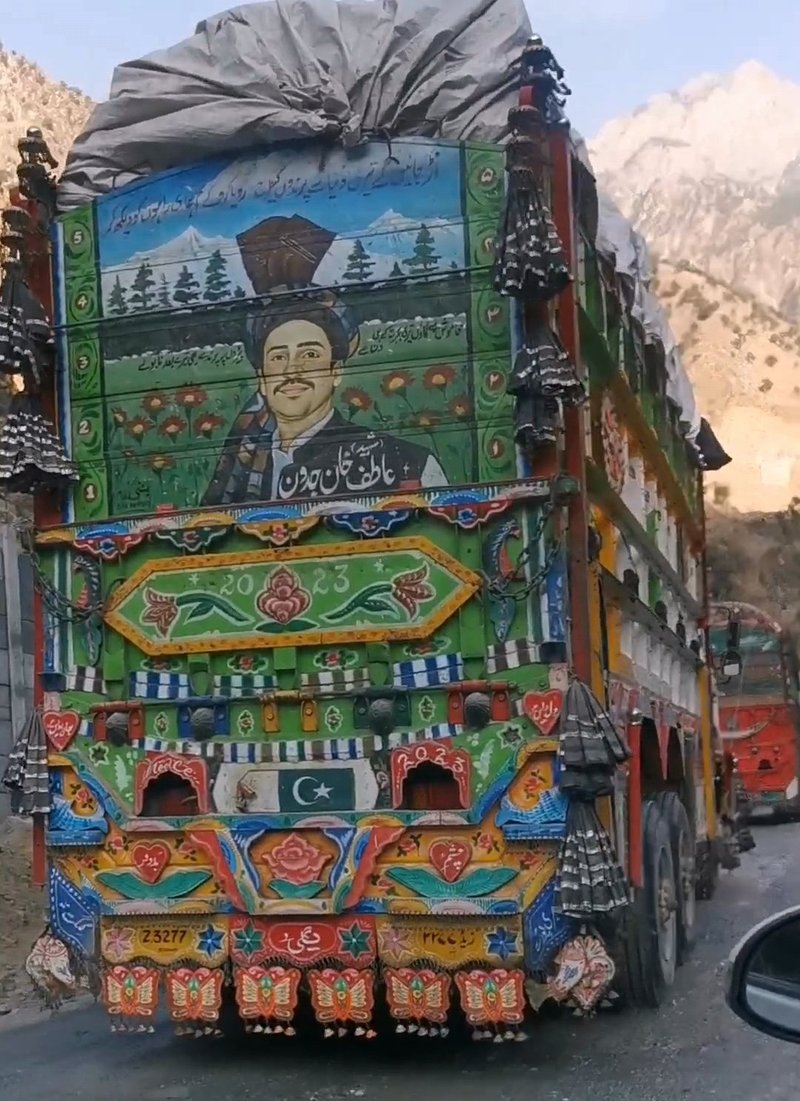
(Pakistani Truck Art)
The trucks are a reason in themselves to visit Sost. They gather at the entrance to the town around the petrol stations and above the village in the dry port. My recommendation: simply take a stroll around and admire the exciting designs of the virtuously painted and decorated vehicles. Apart from the fine ornaments in bright pink, neon yellow, and sky blue, I found the chains of bells, tinsel, and decorative silver balls particularly fascinating. At night, the LEDs are switched on and the trucks light up in the most beautiful colors. Why all this? That's a question to be answered in an extensive cultural science dissertation.

(Truck Art in Pakistan)
Accommodation options are comparatively rare in Sost, but they do exist. One night costs on average between 1500 and 3000 Rupees. Some hotels cater more to road trippers and tourists, and others are reserved for truckers. Another reason to stay here a little bit longer is an excursion to the nearby Chipursan Valley, where you will mainly meet the Wakhi people. They have a close connection with the same culture in the Afghan Wakhan Corridor and their compatriots in Chinese Xinjiang.
 (Because it's pretty: More truck art)
There are also some Wakhi villages in the surrounding area, such as Hussainabad, which may be easier to reach. You should plan at least one night for Chipursan before heading back. If you drive very far into the valley, you can even visit a rather secluded Sufi shrine, the Baba Ghundi Ziarat. Surrounded by the Karakorum mountains and not far from the Afghan border, you can breathe in a purely mystical flair here.

(View onto Sost, the River Hunza, and the Chipursan stream on the left)
On the Hunza bank opposite Sost, the village of Khudabad is mainly inhabited by Burusho or Hunzukuc, who once moved north from the Karimabad region. Sitting on a cliff and observing the river flow, I met the owner of a piece of land here. He sat down with me and told me the story of his family. His grandparents once moved to the barren mountains under harsh conditions, with no fruit plantations back in those days.
The previous generations still lived under the Mir of Hunza, i.e., within an independent kingdom. Today, it is mainly pears, apples, walnuts, apricots, and more that grow here. In addition, the Chinese road has changed a lot and also brings tourists to Sost. In his opinion, it's a curse and a blessing at the same time. Over tea and dried fruit, he opened his mind and soul to me about China, Pakistan, business, and the disappearance of his son – but that would be a whole other long story.
*A tip for communication in 2024/2025: SCOM is the most effective SIM provider in the area, followed by Telenor and Jazz, with a few exceptions. Even though ZONG is currently doing a lot of advertising in the Hunza Valley, the SIM cards from this brand do not work here at all. Alternatively, you can get a Ufone SIM in Islamabad. This state-owned provider is said to use the SCOM-networks once reaching Gilgit-Baltistan.